
The recognition and protection of indigenous peoples, must be accelerated to create customary land maps. AMAN, JKPP and BRWA has handed over 4.8 million hectares of indigenous territories that have been mapped to the government.
Currently, the government has issued a number of policies related to indigenous territories, for example in Malinau district there is already local regulation recognition and protection of indigenous peoples' rights.
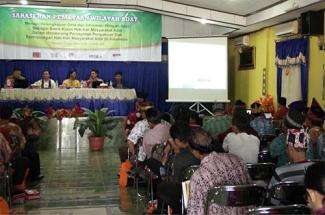
"The regulation also specifically regulates indigenous territories. A map is a tool for the consolidation of indigenous communities, because many indigenous communities are hesitant to admit their communal land, when companies or governments have a map, " said Kasmita Widodo, Head of the Ancestral Domain Registration Agency (BRWA) in the Indigenous Territory Mapping Workshop during the 4th AMAN (Indigenous People's Alliance of the Archipelago) National Meeting, held in Sorong - West Papua, March 16.
Widodo added that customary maps were very crucial to solve occurring land conflicts.
Previously, Arifin "Monang" Saleh, deputy for indigenous people empowerment of AMAN explained: a map of indigenous territories is one the indicators of the presence of indigenous communities. During colonial times maps were tools to the practice of occupation. Indigenous peoples are already familiar with the map for a long time, mainly to define the governance of indigenous territories and determination of jurisdiction between indigenous communities. Determine their borders based on natural borders such as rivers, mountains, sacred places, hunting locations and so on.
"Borders of this nature may change over time and may become unrecognizable by the indigenous people since natural borders may be subjected to new large-scale plantations, mines and zoning administration that ignore the traditional boundaries," Monang explained.
This workshop is to discuss how to accelerate the mapping of indigenous territories and the registration process on maps of the area that have been mapped.
The challenge is to meet certain standards when creating indigenous territory maps. Imam Hanafi of Participatory Mapping Network (JKKP) revealed that such maps have been produced through the work of civil society organizations with people still is in a participatory form. Maps produced in such a way contain land rights.
During four days (16-19 March 2015) AMAN held a National Meeting in Sorong. The meeting was participated by the Board of AMAN, Regional Board (Pengurus Wilayah and Pengurus Daerah), the National Council of AMAN, AMAN cadres in parliament, academics, and others. At the same time also the 4th anniversary of the National Awakening Day of Indigenous Peoples (HKMAN) and the 16th anniversary of AMAN was celebrated.
Minister of Environment Siti Nurbaya and Minister Home Affairs Tjahjo Kumolo were present too and joined in the dialogue with indigenous peoples.
Stories

Samdhana Institute Opens Manila Office at Manila Observatory
Festival PARARA 2023: Celebrating Local Entrepreneurship and Indigenous Products
Partners' solidarity for World's Indigenous Peoples Day
Grant Advisers Meeting in Chiang Mai