
Bada' is an indigenous area in Poso District, Central Sulawesi. Its location in the highlands makes getting there a challenge. The trip from Palu requires 12 hours before arriving in Tentena, Poso. The journey then continues using for four hours to travel a distance of approximately 68 km. However, during the rainy seasons, the trip can take up to six hours, and it's not unusual to find large potholes along the roads.
Bada' is a valley surrounded by mountains, and located within Lore Lindu National Park and indigenous forest. The land is divided by the Lariang River, which splits the territory into two sub-districts: South Lore and West Lore. South Lore comprises the following villages: Gintu Village which is also the sub-district capital, Bewa, Bada'ngkaia, Runde, Bakekau, Bulili, Pada and Bomba Villages. West Lore Sub-district consists of Lelio, Kolori, Lengkeka (sub-district capital), Kageroa, Tomehipi and Tuare Villages. Both sub-districts are located at an elevation of 750 m.
The Bada' indigenous community is consists of five smaller groups: Kolori, Lelio Lengkeka, Kageroa, and Tuare. These tribes live in 14 villages in two sub-districts with an estimated population of 9,000 people.
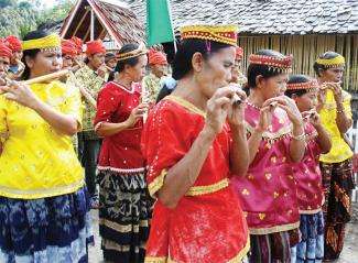
Head of Indigenous People's Alliance of the Archipelago (AMAN) Central Sulawesi Chapter, Rizal Mahfud, explained that the Bada' people, or To Bada', as they are usually called (To meaning people), practice two beliefs in their everyday lives: Islam and Christianity. To Bada' are known to be tolerant and appreciative of differences.
It is rare to find conflicts due to religious differences, said Rizal.
To Bada' are also renown for forest protection. To Bada' regard the forest as an inseparable part of their lives and belief systems, with many rituals symbolising their respect of the forest and surrounding environment.
For every site, the people have their own names, with different functions, Rizal said.
One example is Wumbu Wana. Wumbu Wana is located on the mountaintop where dwarfed trees grow with mossy trunks. This site is a source of water for the surrounding communities.
According to Syukur Tohokeke, a Kolori, Wumbu Wana is restricted from any human access. There are customary sanctions for violators. Forest areas referred to as Wana, with trees of large diameters, are also restricted areas due to their key functions as buffer zones and flood protection.
In addition, there are other areas called Pandulu, secondary forests with endemic wildlife such as anoa and babirusa. This forest is used for collecting non-timber forest products, such as medicinal plants and rattan. Forest product collection is regulated by customary rules.
“The customary rules outline that all forest product collection such as damar and rattan from this area is subject to a 15% fee from the total harvest, which goes to the Customary Forest treasury, said Syukur.
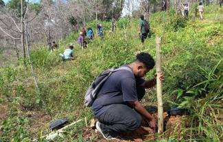
Within Bada' , farmlands which have been abandoned for 5-10 years, called Holu, are planted to support regeneration. Apolos Wengkau, Kageroa Bada' customary leader, notes this is done to rotate farmlands and preserve fertility so that the land can be re-cultivated. Holu can be held by families or individiauls.
Before clearing the land for farms, a traditional ritual is done by holding the skin of a human head or Ohihi, from the wars in the old days. This is to remove evil spirits residing in these areas, Apolos explained.
The people know of another area called Tobu, which are cliffs or sloping areas where two or more rivers meet. These areas are generally not cultivated as farms because of the geographic features that make the land unstable.
Polida'a is community farmlands that the community cultivates for generations. This type of land is owned by individuals, clans, or families. Settlements and other public facilities are called Powanua'a.
There are many archeological remains in the Bada' indigenous land including megalithic rocks which are still around today. For this reason the Bada' land is often called Lembah Purbakala or Valley of the Ancient.
The Bada' indigenous community generally earns their livelihoods from agriculture and farming. The area's potential natural resources include damar, gold, rattan, cacao, rice and rice fields, bamboo, coffee, sugar palm, durian, honey, Pandanus, rambutan, candlenut, langsat, coconut, secondary crops, sago, and others.
According to Rizal, when the Ministry of Forestry designated the land as Lore Lindu National Park (LLNP), To Bada' indigenous land was claimed as part of the park, leading to conflicts between the government and indigenous people.
At first the government argued that the area would only be monitored by the government and the community will not be prohibited from entering the area, but in reality the indigenous community is becoming marginalized, said Rizal.
For the Bada' indigenous people, a number of problems have emerged since LLNP was designated, including limited forest product management of areas located along the boundaroes, prohibited access to areas within LLNP, and obligations of the community to protect the park with no remuneration or guarantees for their livelihoods.
Today, from the 36,100 ha comprising Bada' indigenous territory, only 8,000 ha is recognised as such, he added.
Reference:
Andang, B, et.al., 2013. Menata Kampung: Tiga Komunitas Adat di Sulawesi, Membangun Potensi Menghadapi Dampak Perubahan Iklim. Published by JURnaL Celebes supported by The Samdhana Institute, Indigenous Peoples' Alliance of the Archipelago (AMAN) and Participatory Mapping Working Network (JKPP). Makassar: JURnaL Celebes.
Stories

Samdhana Institute Opens Manila Office at Manila Observatory
Festival PARARA 2023: Celebrating Local Entrepreneurship and Indigenous Products
Partners' solidarity for World's Indigenous Peoples Day
Grant Advisers Meeting in Chiang Mai