
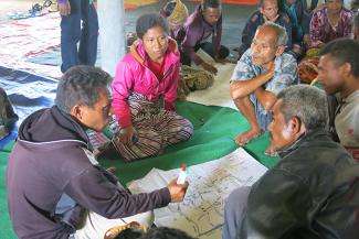
As part of the Large-Scale Participatory Mapping for Mollo indigenous territory, A'Taimamus Organization (OAT) Working Group chaired by Ms Aleta Ba'un, held a three-days training for mapping facilitator.  Thirtytwo facilitators representing Mollo territories - Mutis, Amanatun, Amanuban, and Tobu participated in the training. Three trainers (Imam Hanafi - Participatory Mapping Network, Restu Achmaliadi - Samdhana Institute, and Torry Kuswardhono - PIKUL Association) facilitated the training, and two resorce persons (Hendra Yudhistira of HAKIKI and Joni Iskandar of Talang Mamak indigenous community in Indragiri Hulu District, Riau) were invited to share their experiences on large-scale mapping in their areas.
The training were designed to portray Mollo indigenous communities' structure and roles adopting a participatory approach. The facilitators used a result of study on Mollo's traditions conducted by Ms Aleta Ba'un and Torry Kuswardhono to facilitate more participatory discusion. Beside, the facilitators also used interior of communities' Lapo - a traditional house and pattern of their traditional woven cloth to learn communities' historical background, since communities' traditional history are poorly documented. All those information is very essential for developing a basic customary map.
As of 19-21 March 2014, seven Mollo villages has participated a series of training on participatory mapping. Two communities, Bonleu and Tune has produced a basic customary map which is currently diplayed in their traditional house. The other four, Amaf Banu (Nunbena), Amaf Lasa (Netpala), Amaf Sunbanu (Tobu), and Amaf Makelab (Bes Ana) are beginning to sketch their maps. This basic customary map portray important information of each community's territory such as geography and natural boundaries (i.e. forest, road systems, rivers, streams, and mountains), historical sites (i.e. traditional houses, customary forests, and burial grounds), and settlements areas. In the following six to eight months, communities will verify their basic territory maps with an aerial map made by the Geospatial Information Agency to find out any information deviations with facilitation from Samdhana's partners.
Communities are currently getting more appreciative on the value of territory map of their Amaf. They use the map as a legal evidence to gain outside parties' acknowledgement and minimize conflict with neighboring communities. With facilitation from the OAT Working Group, communities utilise their territory maps to see the existing land use, and establish several associations like farmer and weaver to manage their natural resources sustanably in support of their livelihood security. Communities are also starting to consume more local food for their daily meals to minimize dependency on outside resources.
An important lesson learned during the early stage of Large-Scale Participatory Mapping in Mollo is that the community is becoming increasingly aware of the external threats to their indigenous land, if they cannot prove any legal evident of their land. This evident is legally essential to gain outside parties' acknowledgement of the Mollo territory.
Stories

Samdhana Institute Opens Manila Office at Manila Observatory
Festival PARARA 2023: Celebrating Local Entrepreneurship and Indigenous Products
Partners' solidarity for World's Indigenous Peoples Day
Grant Advisers Meeting in Chiang Mai