
Clarifying Indigenous Rights through Mapping Customary Boundaries in Papua
Posting Date
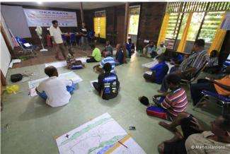
With support from the Climate and Land Use Alliance (CLUA) and the Margaret A. Cargill Foundation, in 2013, Samdhana's Papua Program provided support to mapping activities in three areas: 1) In the Yeinan sub tribal area of Marind in Merauke District, undertaken by SKP-KAM; 2) In Kna Saifi of South Sorong, undertaken by Bentara and; 3) In Moi land covering Sorong Raya, including the three regencies of Sorong, Tambraw, and South Sorong, undertaken by LMA Malamoi. In Sorong and Merauke, Samdhana provided both funding support and technical assistance to facilitate a large-scale mapping process.
Different stakeholders took part in the mapping process as relevant to the specific contexts and demographics of different areas. In Sorong, the mapping process began with stakeholder meetings and discussions that included government, universities, NGOs and community representation in “moiâ€. Meanwhile, the mapping in Kna-Saifi focused on clan and family boundaries.
Customary boundary mapping should be a process driven by the community, as owners of the land, and should ultimately be executed with the community facilitating the process. The quality and accuracy of maps depends on how participatory the process is, and whether it is able to include all relevant actors as resource people, cartographers, and validators.
To ensure an effective process, two series of customary boundary mapping trainings were held. The first training focused on developing the capacity of local facilitators and introducing the ideas and processes of large scale mapping methods. The second trainings centred on identifying and training potential Papuan cartographers on technical mapping and GIS. Samdhana is also working with Papua State University to collaboratively develop technical mapping capabilities of young Papuans.
To date, more than 400,000 ha of customary land has been mapped to date. An important highlight from the mapping process in Sorong is the strong capacity of the customary community institution (LMA) to manage the program and mapping process. LMA Malamoi has been responsible not only for technical activities, but also for communication and projects administration, a role usually undertaken by NGOs. LMA Malamoi has been particularly successful as it is comprised of members who have strong relationships with communities in areas targeted for community mapping. The members have also built effective communication with local government, leading to the provision of support through access to technical maps and necessary devices such as a plotter and base maps.
Samdhana continues to prioritise tenure rights through supporting communities to map their respective areas, getting these maps legally recognized, and alligned with national and sub-national government plans, and assisting communities to prepare and execute a stewardship plan for sustainable management of their natural resources.
Stories

Samdhana Institute Opens Manila Office at Manila Observatory
Festival PARARA 2023: Celebrating Local Entrepreneurship and Indigenous Products
Partners' solidarity for World's Indigenous Peoples Day
Grant Advisers Meeting in Chiang Mai